
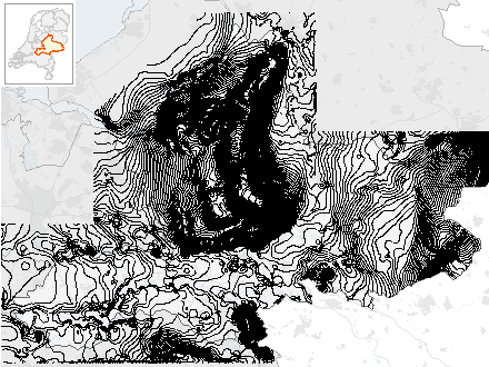
Hydrologie- Isohypsen Gemiddelde Voorjaars Grondwaterstand 1e WVP
Het bestand bevat de Isohypsen (lijnen gelijke grondwaterstand) van de Gemiddelde Voorjaars Grondwaterstand en is gemaakt door NITG/TNO in het kader van het Regionaal Geohydrologisch Informatie Systeem (REGIS). De waarnemingsperiode loopt van 1990 t/m 1998.
- Identification
- Distribution
- Quality
- Spatial rep.
- Ref. system
- Content
- Portrayal
- Metadata
- Md. constraints
- Md. maintenance
- Schema info
Identification
Data identification
Citation
- Alternate title
-
GEO.AbHy_Isohypsen_gvg_tno_wvp1
- Date (Creation)
- 2003-06-30
- Date (Revision)
- 2008-05-02
- Presentation form
- Digital map
- Purpose
-
Overzicht grondwaterstanden Gelderland - Gemiddelde Voorjaarsgrondwaterstand.
- Status
- Completed
- Maintenance and update frequency
- Unknown
-
Interprovinciale thesaurus
-
-
GRONDWATER
-
GRONDWATERSTAND
-
WATER
-
WATERPEIL
-
HYDROLOGIE
-
- Use limitation
-
Geen gebruiksbeperkingen
Legal constraints
- Access constraints
- Other restrictions
- Other constraints
- Geo Gedeeld licentie
- Spatial representation type
- Vector
- Denominator
- 100000
- Language
- Nederlands; Vlaams
- Character set
- UTF8
- Topic category
-
- Geoscientific information
- Environment description
-
Microsoft Windows 10 Version 10.0 (Build 17763) ; Esri ArcGIS 12.5.1.22081
Extent
))
- Begin date
- 1990-01-01
- End date
- 1998-12-31
- Supplemental Information
-
Meer informatie| https://www.dinoloket.nl
Distribution
Distribution
- Distribution format
-
-
SDE Feature Class
()
-
SDE Feature Class
()
(026) 359 9480
http://www.gelderland.nl
Digital transfer options
- OnLine resource
- AbHy_Isohypsen_gvg_tno_wvp1 ( OGC:WMS )
- OnLine resource
- AbHy_Isohypsen_gvg_tno_wvp1 ( OGC:WFS )
Quality
Data quality
- Hierarchy level
- Dataset
Quantitative result
- Value
- Redelijk nauwkeurig, lokale inschattingsfouten kunnen voorkomen: lokale inschatting grondwaterstand altijd kritisch beoordelen.
- Statement
-
Isohypsen bepaald door NITG/TNO in het kader van REGIS-project.
Ref. system
- Reference system identifier
- EPSG / https://www.opengis.net/def/crs/EPSG/0/28992
Metadata
Metadata
- File identifier
- 9913f2dd-87f8-4afd-b6d7-08c6b7e00dd2 XML
- Metadata language
- Nederlands; Vlaams
- Character set
- UTF8
- Hierarchy level
- Dataset
- Hierarchy level name
-
dataset
- Date stamp
- 2021-11-08
- Metadata standard name
-
ArcGIS Metadata
- Metadata standard version
-
1.0
https://www.gelderland.nl
Overviews
Provided by
