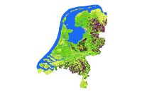
HGN 1900 : Historisch Grondgebruik Nederland 1900
Het bestand Historisch Grondgebruik Nederland is een rasterbestand met een resolutie van 50 meter.(Per 50 * 50 meter gridcel is een grondgebruikklasse bepaald) Het bestand is afgeleid uit de topografische Bonnekaarten rond de periode 1900. Er worden tenminste 10 typen landgebruik onderscheiden. Het bestand is vervaardigd door gescande Bonnekaarten te classificeren. Tevens is onderliggende abiotische informatie beschikbaar.
dutch-default
dataIdentificatie
- Title
-
HGN 1900 : Historisch Grondgebruik Nederland 1900
- Alternate title
-
HGN_1900
- Date (Publication)
- 2004-12-31
- Edition
-
1
- Unique resource identifier
-
8cc1f636-0cfc-46c1-995b-ac9c7ea209b0
- Metadata language
-
dut
- Character set
- UTF8
- Purpose
-
Ontwikkelen van een landsdekkend bestand met historisch grondgebruik.
- Status
- Completed
Contact for the resource
- individualName
-
Henk Kramer
- Organisation name
-
Wageningen Environmental Research
- positionName
-
Inhoudelijk deskundige
- voice
-
0317-481816
- facsimile
-
0317-479000
- deliveryPoint
-
Droevendaalsesteeg 3
- city
-
Wageningen
- administrativeArea
-
Gelderland
- postalCode
-
6708 PB
- country
-
Nederland
- Maintenance and update frequency
- Not planned
-
GEMET - Themes, version 2.4
-
-
Geografie
-
Landgebruik
-
restrictions
Legal constraints
- Use constraints
- Other restrictions
- Other constraints
Security constraints
spatial
- Denominator
- 100000
- Spatial representation type
- Grid
))
- Geographic identifier
- Nederland
- Description
-
dit was afhankelijk van de beschikbaarheid van de kaartbladen bij de start van het project in 2000
- Geographic identifier
- Nederland
- Begin
- 1865-01-01
- End
- 1931-12-31
- Minimum value
- 0
- Maximum value
- 0
Vertical CRS
Vertical CS
Vertical datum
- Supplemental Information
-
website HGN| http://www.hgnnederland.nl/
Alterra rapport 573 HGN 1900| http://www.geodata.alterra.nl/portalen/datadocs/alterra_rapport_573_HGN1900.pdf
Ref. system
Projection
- code
-
Rijksdriehoekstelsel_New (28992)
- codeSpace
-
EPSG
- code
-
n.v.t.
- codeSpace
-
EPSG
Distribution
Encoding
distributorContact
- individualName
-
GeoDesk
- Organisation name
-
Wageningen Environmental Research
- positionName
-
Beheerder
- voice
-
0317-484111
- facsimile
-
0317-479000
- deliveryPoint
-
Droevendaalsesteeg 3
- city
-
Wageningen
- administrativeArea
-
Gelderland
- postalCode
-
6708 PB
- country
-
Nederland
orderProcess
- orderingInstructions
-
via de GeoDesk
- fees
-
Op aanvraag
DataQuality
- Hierarchy level
- Dataset
Conformance result
- Date
- Value
- Geheel Nederland
- Description
-
Scannen topografische kaarten
Georefereren
Classificeren
Digitaliseren
- Processor
-
organisationName electronicMailAddress role Alterra
Processor
- Description
-
bonnekaarten 1 : 25.000
- Description
-
Scannen analoge kaart
- Processor
-
organisationName electronicMailAddress role Alterra, Wageningen UR
Principal investigator
Metadata
- Metadata language
-
dut
- Character set
- UTF8
- Hierarchy level
- Dataset
Contact for the metadata
- individualName
-
GeoDesk
- Organisation name
-
Wageningen Environmental Research
- positionName
-
Auteur
- voice
-
0317-484111
- facsimile
-
0317-479000
- deliveryPoint
-
Droevendaalsesteeg 3
- city
-
Wageningen
- administrativeArea
-
Gelderland
- postalCode
-
6708 PB
- country
-
Nederland
- Metadata standard name
-
ISO 19115
- Metadata standard version
-
Nederlandse metadata profiel op ISO 19115 voor geografie 1.2