
HGN 1900 : Historisch Grondgebruik Nederland 1900
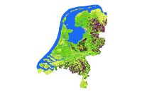
Het bestand Historisch Grondgebruik Nederland is een rasterbestand met een resolutie van 50 meter. (Per 50 * 50 meter gridcel is een grondgebruikklasse bepaald.) Het bestand is afgeleid uit de topografische Bonnekaarten rond de periode 1900. Er worden tenminste 10 typen landgebruik onderscheiden. Het bestand is vervaardigd door gescande Bonnekaarten te classificeren. Tevens is onderliggende abiotische informatie beschikbaar.
- Identification
- Distribution
- Quality
- Spatial rep.
- Ref. system
- Content
- Portrayal
- Metadata
- Md. constraints
- Md. maintenance
- Schema info
Identification
Data identification
Citation
- Alternate title
-
HGN_1900
- Date (Publication)
- 2004-12-31
- Edition
-
1
- Purpose
-
Ontwikkelen van een landsdekkend bestand met historisch grondgebruik.
- Status
- Completed
- Maintenance and update frequency
- Not planned
-
GEMET - Themes, version 2.4
-
-
Geografie
-
Landgebruik
-
Usage
- Specific usage
-
Het bestand kan worden gebruikt als historische referentie (statistiek landgebruik) en als invoer voor modellen en methoden die ook gebruik maken van LGN.
Constraints
Legal constraints
- Use constraints
- Other restrictions
- Other constraints
- Other constraints
- Other constraints
Legal constraints
- Access constraints
- Other restrictions
- Other constraints
- Naamsvermelding verplicht, Wageningen Environmental Research
Security constraints
Aggregate Information
Citation
- Title
-
HGN 1960
- Date (Creation)
- 2006-11-01
- Association Type
- Cross reference
Aggregate Information
Citation
- Title
-
HGN 1990
- Date (Creation)
- 2005-10-13
- Association Type
- Cross reference
- Spatial representation type
- Grid
- Denominator
- 100000
- Language
-
dut
- Character set
- UTF8
- Topic category
-
- Imagery base maps earth cover
Extent
- Description
-
dit was afhankelijk van de beschikbaarheid van de kaartbladen bij de start van het project in 2000
))
- Geographic identifier
- Nederland
- Begin date
- 1865-01-01
- End date
- 1931-12-31
Vertical extent
- Minimum value
- 0
- Maximum value
- 0
Vertical CS
Vertical datum
- Supplemental Information
-
website HGN| http://www.hgnnederland.nl/
Distribution
Distribution
- Distribution format
-
Digital transfer options
- OnLine resource
- Downloadpagina HGN ( landingpage )
Quality
Data quality
- Hierarchy level
- Dataset
Quantitative result
Quantitative result
- Value
- Geheel Nederland
Conformance result
Citation
- Date
Quantitative result
Lineage
Process step
- Description
-
Scannen topografische kaarten
Georefereren
Classificeren
Digitaliseren
Source
- Description
-
bonnekaarten 1 : 25.000
Process step
- Description
-
Scannen analoge kaart
Metadata
Metadata
- File identifier
- d0c1e1b3-8c4a-4858-b43f-2465268fab18 XML
- Metadata language
-
dut
- Character set
- UTF8
- Hierarchy level
- Dataset
- Date stamp
- 2026-02-26
- Metadata standard name
-
ISO 19115
- Metadata standard version
-
Nederlands metadata profiel op ISO 19115 voor geografie 2.1.0
)))
