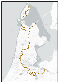
Noord-Holland Pad
Het Noord-Hollandpad is een gemarkeerde lange- afstand-wandelroute (circa 270 kilometer) van Wieringen of Texel naar het Gooi. http://geo.noord-holland.nl/nh_pad/start.html
Standard
dataIdentificatie
- Title
-
Noord-Holland Pad
- Date (Creation)
- 2021-10-07
- Date (Publication)
- 2021-12-10
- Unique resource identifier
- c871c932-e1f2-4d56-845d-e85dd8278881
- Status
- Under development
- Metadata language
- Nederlands; Vlaams
-
GEMET - INSPIRE themes, version 1.0
-
-
recreatie
-
wandelpaden
-
wandelroutes
-
- Keywords
-
-
Downloadable Data
-
- Use limitation
-
geen beperkingen
Legal constraints
- Access constraints
- Other restrictions
- Other constraints
- Geo Gedeeld licentie
- Point of contact
-
individualName organisationName electronicMailAddress role Roy Oosterom
Recreatie Noord-Holland
Distributor Kaart en Data (BEL/OI)
Provincie Noord-Holland
Custodian
spatialInfo
N
S
E
W
))
- Denominator
- 1000
- referenceSystemIdentifier
DataQuality
- Hierarchy level
- Dataset
- Lineage
-
Gedigitaliseerd op luchtfoto
Metadata
- Metadata language
- Nederlands; Vlaams
- Hierarchy level
- Dataset
- Metadata author
-
individualName organisationName electronicMailAddress role Kaart en Data (BEL/OI)
Provincie Noord-Holland
Author
)))