
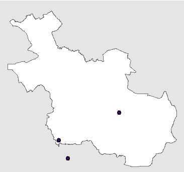
Wateraanvoerpunten
Sluis Eefde, sluis Aadorp, gemaal Ankersmit (Deventer). Via deze punten kunnen gebieden in tijden van droogte vanuit het Hoofdsysteem van water worden voorzien. In Overijssel is de bron hiervoor voornamelijk de IJssel. De belangrijkste transportroute is via het Twentekanaal.
Standard
dataIdentificatie
- Title
-
Wateraanvoerpunten
- Date (Creation)
- 2014-01-27
- Date (Publication)
- 2021-02-04
- Date (Revision)
- 2014-01-27
- Unique resource identifier
-
f01565d8-23ba-40ff-a485-4ebf09e46f9b
- Status
- Completed
- Metadata language
- Nederlands; Vlaams
-
Interprovinciale thesaurus
-
-
wateraanvoer
-
Constraints
- Use limitation
-
Geen gebruiksbeperkingen
- Use limitation
-
Geoportaal extern
- Use limitation
-
Downloadable data
Legal constraints
- Access constraints
- Other restrictions
- Other constraints
- Other constraints
-
Geo Gedeeld licentie
- Point of contact
-
individualName organisationName electronicMailAddress role team Data, Informatie, GIS en Innovatie
Provincie Overijssel
Owner
spatialInfo
))
- referenceSystemIdentifier
-
https://www.opengis.net/def/crs/EPSG/0/https://www.opengis.net/def/crs/EPSG/0/28992
DataQuality
- Hierarchy level
- Dataset
- Hierarchy level
- Dataset
- Lineage
-
Provincie Overijssel
Metadata
- Metadata language
- Nederlands; Vlaams
- Hierarchy level
- Dataset
- Metadata author
-
individualName organisationName electronicMailAddress role team Data, Informatie, GIS en Innovatie
Provincie Overijssel
Owner
Overviews
)))
Provided by
