
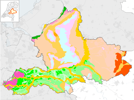
Bodem- Lithologische kaart
Het bestand met de globale opbouw van de bovenste 10 meter van de bodem in zeventien profieltypen (lithologische eenheden). Voorbeeld profieltype: M = zand en grind. Lithologie betekent letterlijk "gesteente" of "gesteentekunde". In de geologie wordt de term gebruikt om aan te geven met wat voor soort steen men te maken heeft.
Standard
dataIdentificatie
- Title
-
Bodem- Lithologische kaart
- Date (Creation)
- 1987-12-31
- Date (Revision)
- 1987-12-31
- Unique resource identifier
- 355e35d7-dfe8-430c-a7fa-2395814ce449
- Status
- Completed
- Metadata language
- Nederlands; Vlaams
-
Interprovinciale thesaurus
-
-
BODEMKAARTEN
-
BODEM
-
NATUUR EN LANDSCHAP
-
GRONDWATERSTAND
-
- Use limitation
-
Geen gebruiksbeperkingen
Legal constraints
- Access constraints
- Other restrictions
- Other constraints
- Geo Gedeeld licentie
spatialInfo
))
- Denominator
- 250000
- referenceSystemIdentifier
DataQuality
- Hierarchy level
- Dataset
- Lineage
-
Rapport “Toelichting bij de lithologische kaart van de provincie Gelderland schaal 1:250.000.†Haarlem, Rijks Geologische dienst, juni 1987
Metadata
- Metadata language
- Nederlands; Vlaams
- Hierarchy level
- Dataset
- Metadata author
-
individualName organisationName electronicMailAddress role ProvincieLoket
Provincie Gelderland
Point of contact
Overviews
Provided by
